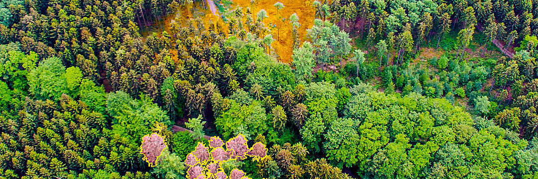
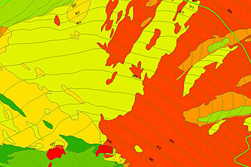
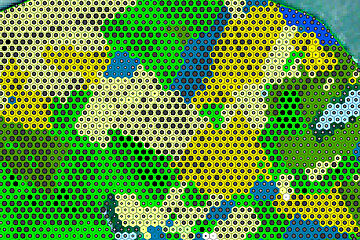
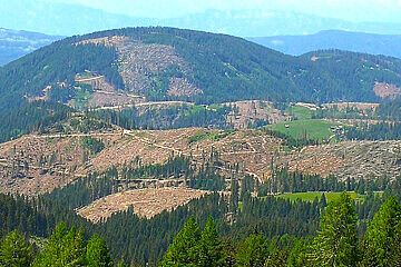
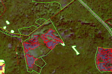
Contact

The sustainable protection and successful management of our forest is a social, governmental, economic and individual responsibility and challenge. The effects of increasing natural disasters and climate change are clearly visible in our forests. Foresters and silviculturists are often confronted with a damaged forest - caused by calamities, storm blowdown or drought.

Forest characterisation has so far been time-consuming, cost-intensive and carried out in a 10-year rhythm (forest inventory). Accelerated changes in forests require more frequent monitoring of forest areas. Satellite and aerial photography data make it possible to update forest data from the air at shorter and more flexible intervals. Digital automated analysis procedures/methods provide important information for early detection. This information can be used to develop measures to reduce forest damage and to guide sustainable strategic forest conversion.
 

ForestMonitor - individual forest information

Our ForestMonitor provides annual information up to ad-hoc statements of high quality. You benefit from tailor-made solutions and individual advice.

Our service includes the following services, which can be combined in modules:

Forest Terrain

You will receive information on the area characteristics such as slope, exposure and altitude.

Forest Inventory

Tree species, tree heights and crown closure levels help to characterize your forest.

Forest Damages

We offer demand-oriented analyses of damage events such as storm damage, snow breakage, drought damage and pest infestation in the desired time window.

Forest GIS Management

Digitization services, geodatabase management, acquisition and evaluation of current aerial and satellite image data are available through our forest GIS management.

Analysing the forest of tomorrow

Soil erosion can increase as more open spaces are created by damage. Prevent it:

  • Risk analyses, e.g. potential landslide areas, floods and inundations, forest fires
  • Damage analyses/post-disaster analyses, e.g. determination of extent of damage and emergency aid
  • Vitality analyses
  • Scrub analyses

With our remote sensing analyses, you will be able to identify potential stress factors and natural hazards at an early stage and respond on them.

External content - YouTube

This is a placeholder for third party content, please click to activate.

The external provider might be able to collect user specific data by activating this content. For more information please check out our data protection.


Talk to us. Whether you are a federal ministry, a state office, a forestry association or a private forest owner - our solutions can be adapted to any application.


These partners trust us:

  • Bavarian State Institute for Forestry and Forestry (LWF)
  • Hesse Forest
  • Thuringia Forest
  • Saxony Forest
  • Landesbetrieb Wald und Holz NRW
  • Intend Geoinformatics GmbH
  • US Army Corps of Engineers
  • EU Joint Research Centre (JRC)

Current publications:

KIHBA - Artificial intelligence for high-resolution tree species recognition

Forests are subject to rapidly increasing climate change-related changes as well as abiotic and biotic calamities. Comprehensive knowledge of tree species composition and tree species distribution is therefore of utmost interest for forest management and forms the basis for sustainable forest conversion. Currently, this information is only available for about 34% of the Bavarian forests (state forest) from sample inventories.

The aim of the joint research project of IABG and LWF Bavaria is to develop an AI-based methodology for automated tree species classification of the most economically important tree species in Bavaria (and Germany) - spruce (Picea abies), pine (Pinus sylvestris), beech (Fagus sylvatica) and oak (Quercus spec.) - on the basis of high-resolution remote sensing data.

The tree species classification is implemented using Deep Learning. To train the Convolutional Neural Networks (CNN) used for this purpose, a very extensive training data set was generated through visual interpretation and manual digitisation of individual trees and tree species groups. The model is currently being trained and optimised.

The project is funded by the German Space Agency at the German Aerospace Center (DLR) with funds from the BMWi.
 

BeechSAT and IpsSAT

Artificial intelligence (AI) and aerial/satellite imagery at work for the forest.

In recent years, the proportion of dying or dead trees has increased sharply. Thus, beech dieback has been observed in northern Bavaria since the beginning of 2019. The amount of damaged wood caused by the infestation activity and population development of book printer (Ips typographus) and copper engraver (Pityogenes chalcographus) also increased rapidly: 1.9 million fm in 2016, 3.55 million fm in 2017 and 4.5 million fm in 2018 (Triebenbacher et al. 2017, 2018 & 2019).

These two phenomena prompted the Bavarian State Institute for Forests and Forestry (LWF) and IABG to launch the research projects BeechSAT - detection of beech drought - and IpsSAT - detection of different stages (red- and grey-attack) of bark beetle infestation. Different optical satellite data and aerial images for remote sensing detection and different machine learning (ML) and deep learning (DL) methods were compared. The study was carried out in representative study areas in Bavaria.

The aim of the projects was to assess the benefits of the methods used for forest owners (economic, ecological, social) and forest protection (phytosanitary). A particular focus was on assessing the practical suitability of high-resolution, optical satellite data for the automated detection of bark beetle damage and beech drought and the derivation of recommendations for the implementation in a practice-ready procedure.

 Machine LearningDeep Learning
ApproachRandom Forest, Support Vector MachineU-Net based architecture
Image dataAerial Photo, WorldView-2/3, SkySAT, PlanetDove, Sentinel-2Aerial Photo, WorldView-2/3, SkySAT, PlanetDove, Sentinel-2
Training dataRepresentative training polygonsArea-wide label image tiles
 Manual recording of training data based on TrueDOPsManual recording of training data based on TrueDOPs
 Manual acquisition of training polygonsSemiautomatic acquisition of training polygons (image segmentation)
TrainingR,G,B,NIR channels Vegetation indices, texture featuresR,G,B,NIR channels Vegetation indices, texture features


Marginal Lands

The Marginal Land (MAIL) project aims to identify potential carbon sinks (e.g. fallow land, wasteland, forest-free slopes) across Europe and evaluate their usability for afforestation. A tool will be developed to identify potential afforestation areas for CO2 storage and to adapt them accordingly. A specific site characteristic to be modelled is the carbon sequestration potential of biomass over the medium term . The integration of current Copernicus data enables the visualization of the development of potential carbon sink areas. This is intended to raise awareness of marginal land management and to provide access to a wider range of users. A related platform will provide on-demand thematic maps for entire Europe to policy makers, stakeholders, or researchers with.
IABG identifies potential carbon sinks in Germany and Europe and analyses their applicability in sustainable climate programs.
All activities are funded by Horizon 2020/ MSCA-RISE 2018.
MAIL (Identifying Marginal Lands in Europe and strengthening their contribution potentialities in a CO2 sequestration strategy, GA No. 823805, H2020-MSCA-RISE-2018) is a European collaborative project of different European research institutions and companies funded by the Research Executive Agency (REA).

Contact

IABG Geodata - Forest

Tel. +49 3518923-134 • forst@iabg.de